Cuyamaca Peak is the second highest point in San Diego County and is located towards the western edge of Cuyamaca Rancho State Park. You can access the trail through Lookout Fire Road at Paso Picacho Campground. This road up to the trail is paved and it's the only hike in the park that dogs are allowed on. It's a moderately strenuous 6 miles hike with an ascent of about 1539 feet.
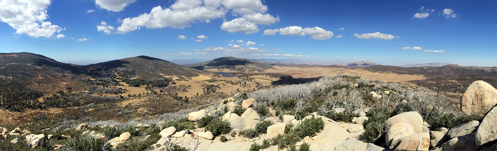
The peak’s elevation at 6,512’ is at the geographic center of San Diego County offering unparalleled panoramic views to the ocean.
The peak is the dominant landmark in vast Cuyamaca Rancho State Park. This parcel was once covered by a rich mixed-conifer forest, interspersed with chaparral, oak woodlands, and gentle meadows fringed with pines. The land was originally inhabited by the Kumeyaay Indians, who referred to the area as “Ekwiyamak,” which translates roughly to "the place in the clouds" or “the place where it rains.” The region receives an average of over 30 inches of precipitation per year due to its higher elevation, which supported the forests and gave birth to the Sweetwater River.
Azalea Glen Loop Trail
The Azalea Glen Loop begins at Paso Picacho Campground and the trail consists of several single track trails with wider fire roads. The trial features many loops but is well marked & make sure to stay on course & read the trail markers. It's a moderate 4-mile loop that features streams & you can still see the effects of the 2003 Cedar fire to devastated the park. A lot of the trail is shaded & is suitable with small bridges & grassland areas.
Conejo Spring Trail
Moderately strenuous 3.5 sometimes steep miles to summit. Gain in elevation 1650 ft. Rugged ascent over the north shoulder of Cuyamaca Peak. Trail is a streambed after heavy rain or snow melt. Connects to paved road leading to summit. Descent to campground by paved fire road. Trail head and parking at Pasa Picacho Campground.
Green Valley Falls Trail
Easy .75 mile one way, suitable for children. Well-marked trail to pretty, seasonal waterfall. Best in spring and early summer. Trailhead and parking located at picnic area parking lot at Green Valley Campground.
Indian Trail
Easy one mile level, scenic, and suitable for children. Self-guiding trail leading to an old Indian village site, plaques describe Indian uses for common plants. Trail head and parking by the flagpole at the park headquarters/museum parking lot.
Juaquapin Trail
Moderate 3 mile scenic loop climbing via East Site Trail with a steepish return by Dyar Spring Trail. Gain in elevation 400 ft. Well-graded trail through oaks, manzanita, chaparral and open meadows and stream with wildflowers and deer. Trail head and parking at turnoff for Museum/Park headquarters or a Sweetwater Bridge.
Paseo Nature Trail
Easy .5 mile loop, scenic, level, and suitable for children. Self-guiding trail with 16 trail signs explaining various natural and cultural resources of the area. Trailhead and parking at north end of picnic area at Paso Picacho campground.
Oakzanita Peak Trail
Moderately strenuous 8 mile loop, gain in elevation 1300 ft. Long steady climb leads to extensive vistas particularly from the peak. Trail has little shade and is hot in the summer. Trail head and parking - first paved parking area when entering Cuyamaca Park from the South on Highway 79. Moderately strenuous 5 mile loop. Gain in elevation 1200 ft. Steady climb leads to extensive vistas, first to the coastline and later over East Mesa. The hike follows the fire road to Arroyo Seco primitive camp, then by cut-off trail to West Mesa Trail and Monument Trail.
Stonewall Peak Trail
Stonewall Peak is a popular hike due to its relatively short and easy climb to some beautiful sweeping views of the Rancho Cuyamaca State Park & Lake Cuyamaca. This trail also starts at Paso Picacho Campground and is an easy to moderate 4 mile hike. Around ⅓ of the way you'll encounter a path straight ahead blocked by an “AREA CLOSED” sign. Stay to the right around the closed section and head straight to the peak looming above. As you continue on the trail you'll eventually find yourself at the base of pile of large granite boulders and slabs. Carefully made our way up the rocks on the east side of the rocky expanse until we found the metal pipe railing and stairway carved into the granite boulders. It's a short walk from there and it will be well worth the view once you're at the top.
Moderate 2 miles each way, steady gain in elevation of 900 ft. Suitable for energetic youngsters. Well graded trail through chaparral, oaks and incense cedar to the summit of Stonewall Peak, last section on exposed ridge but with steps and handrail. Great views from peak. Trail head and parking across from entrance to Pasa Picacho campground at the picnic area. Day use fee.