
There is no better place in San Diego to stargaze than our backcountry mountains. We're fortunate to not have very much light pollution at these elevations, which makes for the most splendid star gazing encounters. Each one of our sites is also provided with a a state of the art Trilluim Hammock by Tentsile, which allows you to enjoy the dark sky well into the night. Many of our visitors opt to sleep out on the hammock during summer nights.
About the Laguna Mountain observatory from SDSU web-site:
Mount Laguna Observatory (MLO) is operated by the SDSU Department of Astronomy to support its research, training, and educational programs. Current institutional partners include the University of Illinois at Urbana-Champaign (UIUC) and the University of Kansas (KU). MLO is located 45 miles east of downtown San Diego at a dark site in the Cleveland National Forest at an altitude of 6100 feet (1859 meters). This site is well protected from the urban lighting of the San Diego metropolitan area. Its remoteness, along with the high percentage of clear nights and excellent seeing, makes Mount Laguna one of the best overall observatory sites in the continental United States.
The three major research instruments and their auxiliary equipment are: the 50-inch (1.25-meter) Phillips Claud reflector with KU, currently under construction (4K^2 CCD camera system); the 40-inch (1.0-meter) reflector with UIUC, manufactured by Astro Mechanics, Inc. (two CCD cameras, Cassegrain spectrograph, near-IR camera, automated photometer, Coude bench spectrograph); and the Clifford Smith 24-inch (0.6-meter) reflector (automated photometer, SBIG CCD camera). Our students lead observational projects with these telescopes under the advisement of the faculty. A five bedroom apartment building, four bedroom dormitory, and large shop building are also located on site. Instrument and CCD development are carried out at the on-campus mechanical and electronics shops. Observatory support staff includes a resident astronomer, an engineer, and the observatory superintendent.
Sky conditions at MLO are photometric 60% of the time and spectroscopic 75% of the time. The poorer weather usually occurs in late winter and early spring (February and March). The summer monsoon conditions that plague Kitt Peak in July and August are greatly moderated at MLO. The sky glow from San Diego and other urban areas contributes only about 5% at the zenith on moonless nights. Thus, on these dark nights, the sky brightness at the zenith in the Johnson B filter averages 22.8 magnitudes per square arcsecond. Seeing is generally less than two arcseconds and frequently less than one arcsecond.
The Reginald Buller 21-inch (0.5-meter) visitors’ telescope, manufactured by J.W. Fecker, Inc., is used for instructional support of our General Education Astronomy classes and labs and for special SDSU public outreach programs. This classic telescope has superb optics for viewing by eye.
For information about the MLO Summer Visitors Program, please call 619-594-1415.
Our San Diego mountains offer many bird watching opportunities including Bald Eagles at Lake Cuyamaca.
This vast open area, surrounded by rugged hills, is a great place to spot raptors, such as hawks, golden eagles and owls. The lake also attracts waterfowl, gulls, Red-naped and Red-breasted Sapsuckers, Lewis' Woodpeckers and mountain bluebirds.
With over 50 miles of system OHV trails and roads that traverse through beautiful scenery and challenging terrain, you can find many of the OHV recreational opportunities conveniently located in Corral Canyon, as depicted in the OHV Area Use Map. This guide is designed to provide the off-highway vehicle enthusiast with information, regulations, and travel tips while using National Forest lands. Trails in this area can vary in elevation and difficulty from 3,400 feet at Corral Canyon Campground to 4,169 feet at Bronco Peak. Off-highway vehicle recreation is just one of the many useses allowed on the National Forest. Please ride with care and always watch for other vehicles. Off-Highway Vehicle Route Markers are found on designated OHV trails. On these markers you will find signs and decals designating the type of use recommended, level of difficulty, and system number which corresponds to the map and guide. The OHV guide/map may be obtained at any forest office. Markers with signs, or decals with a red slash mean the route is closed to that type of use. Spark arresters are required year round.
Please visit US Forest Service web-site for important info.

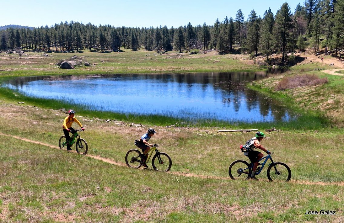
Among the funnest and thrill activities available in our San Diego Backcountry is mountain biking. There are numerous mountain bike trails to choose from that are very close to our glamping sites. Big Laguna Trail and Noble Canyon are 2 of the most popular and can be done as one long track. SDMBA, in collaboration with US Forest service have been supporting the growth of mountain bike trail development in the Laguna Mountain Recreation Area. They've done some amazing work over the years and it's thank to them that we can enjoy this network of trails.
You can visit SDMBA web-site for more info, as well as MTB Project.
We're looking forward to hosting you soon and thank you for your support. Our Kickstarter drive will start on March 1st, 2019 and we have 30 days to reach our goal of $25,000. We have up to 12 pledge options to choose from; including group retreats, Alter Experiences swag, party on the mountain and much more, which you can see below. We'll keep you posted on our #KickstartGlampingSanDiego campaign. We look forward to setting some new and exciting tourism trends in San Diego.
Learn a little more about our tourism model from our company co-founders:
Outside of the Laguna Mountain Recreation Area are also numerous hikes to enjoy and explore. The most popular by far is the 3 Sisters Falls Trail. This is a very difficult trail and we've had many instances of hikers dehydrating and having to be airlifted out of there. This causes a lot of stress on our first responders and we ask that you please make sure you're prepared to undertake this hike. This is not a hike for beginners.
Gaining in popularity, this often crowded, yet challenging hike takes hikers through several ecosystems before leading to the main event - three large waterfalls wedged between tall, rocky mountains. Recently having undergone some new development, hikers will find a safer and more direct route to the falls, which alleviates the requirement to rock/mountain climb, lowering injury risks and casualty rates. Those who are interested in extreme hiking, mountain climbing, rock traversing, or otherwise challenging hikes will still appreciate elements of this trail, particularly if hiking to the third waterfall or traversing the rocky bottom. Those who are new to hiking, or are hiking the trail for the first time, should attempt to complete this in the cooler winter or spring months and allow ample time for the trip down and back out. It is not uncommon to see several heat related air rescues on any given day during the summer months. If you choose to hike this in hotter weather, start early and take at least a gallon of water per person.
Special Features: While the Three Sisters Trail provides wonderful scenery for bird watching and scneic, wide ranging vistas of the Cuyamaca, Sunshine, and El Cajon mountains, it is perhaps best known for the 3 dynamic waterfalls it is named after. During the winter and spring seasons, or during a wet year when the Cuyamaca Reservoir is full, Boulder Creek can experience heavy water flow, resulting in higher than average falls. In prime conditions, the “middle sister” is impressive, with water falls cascading 50 feet into a kidney shaped pool estimated to be about 10 feet deep. Be careful treking this area - the years of water runoff has left the large boulders incredibly smooth, making slips and falls common. Expect water levels to fluctuate with the season. During much of the summer, or in times of drought, the waterfalls and pools can be more of a trickle and a pond, with little in terms visual appeal or swimming potential. If hiking in the spring months when nature is in full bloom, poppies and wild mustard light the horizon with color, while peregrine and prairie falcons prepare their nests for incoming chicks. More info....
The path through Boulder Creek road also offers various hiking opportunities for different skill levels. It is an extremely rich and unique habitat that runs from Descanso to North Peak.
Situated 4,200 feet above sea level in a forest of pines and oaks along the northern extremity of the Cuyamaca Mountain Range in the unincorporated community of Julian sits William Heise County Park. The day-use and camping park spans over 1,000 acres bringing unique features to life, every season, from playful winter snowfall and vibrant spring wildflowers to starry summertime skies and the changing colors of fall. Every trip is a new experience, with new places to visit and new sites to see. Mule deer are frequently seen through - out the park as well as large flocks of Rio Grande Turkey. Other common visitors include the gray fox, bobcats, raccoons, steller’s jay, hawks, golden eagles and the occasional mountain lion
William Heise County Park is home to a number of trails that vary in both difficulty and geography. The Desert View Trail meanders past the Self-Guided Nature Trail to a scenic overlook where on a clear day, views of the Salton Sea to the east and the Pacific Ocean to the west can be seen. If you choose to extend your hike, you have the option to connect to the 1.65-mile Canyon Oak Trail. The 5.75-mile Kelly Ditch Trail takes adventurers south all the way to Lake Cuyamaca and offers equestrian and biking options in addition to hiking. The Fern Trail is a 0.5-mile connector of the Kelly Ditch that takes you into a riparian area alongside the tranquil waters of the Cedar Creek. You can expect to find shady, vibrant green foliage with a nice view to the west on the 1-mile Cedar Trail. View the map for locations of these and other trails on site
The Santa Ysabel Preserves are surrounded by oak woodlands, native grasslands and fields of wildflowers. Set in a beautiful natural landscape of gently rolling hills, hikers, cyclists, and equestrians will enjoy an outdoor adventure within this combined 3,800-acre sanctuary. Discover 15 miles of trails through both the East and West Preserves including two loops that traverse through unique habitats – over the river and through the woods!
There are more than 11 miles of open trails on the East side and nearly 4 miles of open trails on the West side of the preserve.
For your safety, stay on trails and avoid playing in the creek. Carry plenty of water, dress in layers, and wear sunscreen and appropriate footwear.
To prevent damage to the trails, after any inclement weather (1/2 inch of rain or any snow), the preserve will be closed until the trails dry out.
Overnight camping is not allowed.